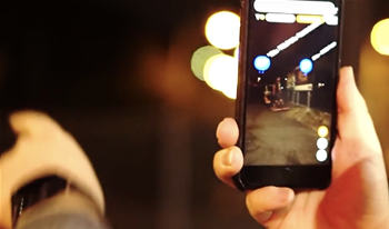
Sydney Trains is using augmented reality to improve worker safety, particularly in the ‘danger zone’ - all space within three metres of a rail line.
Development of the smartphone based mobile app was first revealed at an asset management conference last year, though the app - Track AR View - has been shown off more publicly in the past month.
Senior manager of digital products and applications Ernie Lam told the recent Tricentis virtual summit that Sydney Trains was interested in “how AR, potentially coupled with [a] mobile app, could increase safety on the tracks”.
Track AR view was designed with two goals in mind, according to a video shown at the summit - to “reduce the incidence of incorrect possession protection placement”, and to “improve productivity and reduce time in the danger zone”.
A posession is the process of closing a rail line for maintenance or capital works in the danger zone.
Possessions are marked with a mix of clamps (“point clips”), visual possession limit markers (such as a light, cone and flag), and with small explosive devices designed to warn a train as a last resort.
Lam said the app assists workers to locate assets “quickly in all kinds of conditions and then perform their role safely and then get out of that danger zone”, pointing them to the nearest boundary gates.
The app also validates that possession markers are in the right spot; a white paper from the summit last year, viewable in cache, states that “in the past several years, three-to-five incidents a year” were caused by “difficulties in locating the right assets for placing possession protection and placement of point clips incorrectly”, leading to “workers entering unprotected areas unknowingly”.
The app resolves this by directing workers to assets using satellite navigation and AR, providing mobile access to information held about that asset, and digitising the workflow for placing and removing point clips, which includes capturing and submitting geocoded photos from the field.
“A possession manager (at the management centre) receives a photo and location of the protection being placed, allowing them to verify it is the correct placement, in addition to GPS and date/time metadata that can be plotted in the management centre, adding a further layer of safety to the process,” the Rail Industry Safety and Standards Board (RIISB) wrote in its newsletter [pdf] last month.
Lam said that the app was trialled “on the track in night-time conditions” and that it is now in the process of being continuously improved.
“That’s where we’re at now, we’re continuously taking that feedback on board and going back to make further enhancements,” he said.
Sydney Trains uses Tricentis to test new releases of software, including its mobile applications.
